This post may contain compensated links. Find more info in our disclosure policy
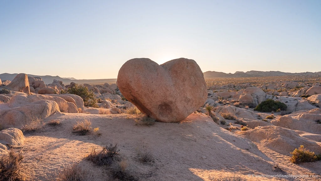
Heart Rock is, as the name suggests, a perfectly heart shaped rock set in a boulder field in Joshua Tree National Park. With no marked trail to follow, Heart Rock remains one of Joshua Tree’s hidden gems. It took us two attempts to find Heart Rock on a recent trip to Joshua Tree and we met a few other hikers also on the hunt for the heart shaped rock! Having successfully located and fallen in love with Heart Rock we’ve put together this guide on how to get to Heart Rock in Joshua Tree National Park together with the exact location of Heart Rock in Joshua Tree.
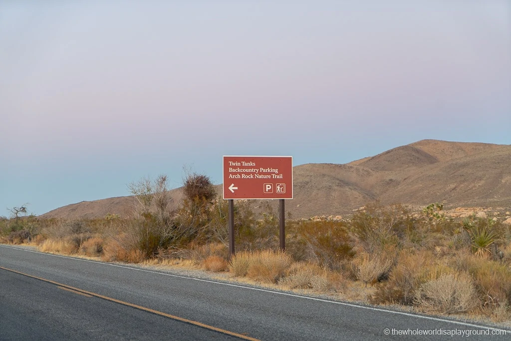
Heart Rock is now a marked trail in Joshua Tree National Park. Remember to bring lots of water.
Heart Rock
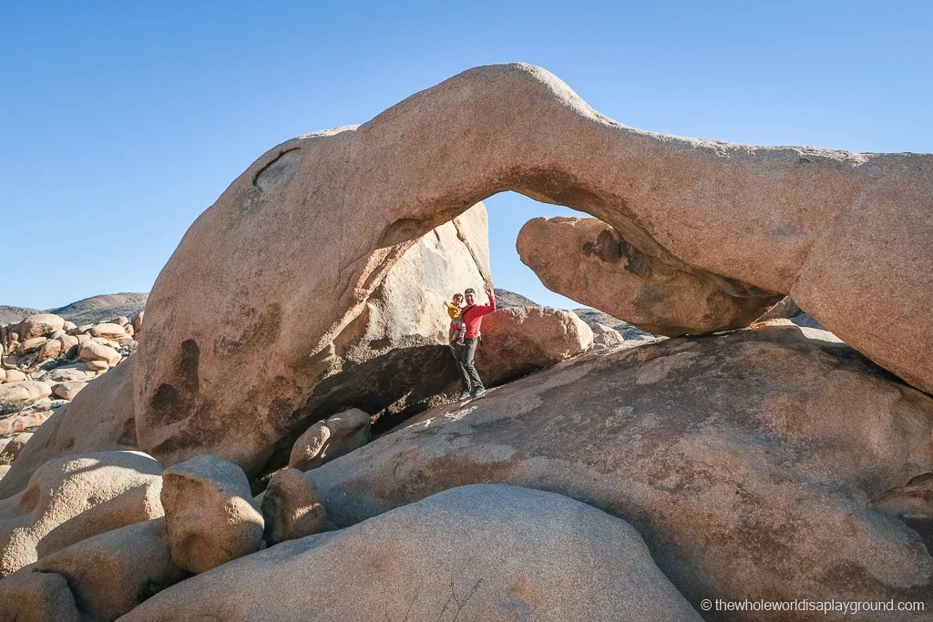
Heart Rock is a unique rock formation shaped like a heart which is located close to the Arch Rock trail in Joshua Tree National Park. The rock itself is around 10 feet tall and rises above a boulder field close to the famous Arch Rock deep in the Joshua Tree desert.Heart Rock Joshua Tree For Instagram fans, Heart Rock is one of the best Instagram spots in Joshua Tree!Heart Rock
Where to Stay in Joshua Tree
The North Entrance (Twentynine Palms) and the West Entrance (Joshua Tree town) are the most convenient for visiting many of the Joshua Tree National Park highlights. These are our top 3 places to stay in Joshua Tree and are perfect for couples, small groups and families:
M&L Desert Cottage: this beautiful 2 bedroom cottage is just 6 minutes drive from the north entrance to Joshua Tree. The cottage has been completely remodeled and is the definition of desert chic. The interior is gorgeous and there is a fire pit, BBQ and hammocks on the patio for stargazing and al fresco dining. – check prices now!
Location: North Entrance/Twentynine Palms. We love this entrance as it’s both close to many highlights of Joshua Tree National Park and is also a much quieter gate to enter the park by. M&L Desert Cottage is a 20 minute drive from Joshua Tree Town.
Castle House Estate: with the accommodation options including guard towers, yurt tents, a tiny container house (the perfect chance to experience tiny home living!) and a vintage RV, Castle House Estate perfectly encompasses the unique Joshua Tree vibe. It’s the perfect mix of indoor and outdoor living and the accommodation is beautifully presented and incredibly unique. The hardest part is choosing which accommodation to reserve – check prices now!
Location: West Entrance/Joshua Tree. Castle House Estate is a 10 minute drive from Joshua Tree Town and is 20 minutes north of the park entrance.
Fairfield Inn & Suites by Marriott Twentynine Palms – clean and well equipped, the Fairfield Inn is one of our go to hotels when we’re exploring the park and want somewhere clean and quiet to rest up. The hotel has a small pool out back, free breakfast, laundry facilities and there’s a grocery store just across the road for supplies – check prices now!
Location: North Entrance/Twentynine Palms. We opt for the convenience of the Fairfield Inn when we have early starts and late evenings in the park.
We’ve put together the below map of the hiking route to Heart Rock. Arch Rock trail is shown in Yellow, with the detour to Heart Rock in Orange. To get to Heart Rock you will need to take an unmarked rail off the Arch Rock trail. While it’s a relatively easy detour it is very easy to get lost among the endless rocks in Joshua Tree National Park. We highly recommend saving the GPS location of the rock and the surrounding area on an offline map app before you visit Joshua Tree to avoid getting lost. There is almost no cell-phone reception in Joshua Tree National Park so make sure to save the location on Google Maps ahead of time. The exact coordinates of Heart Rock are: 33°59’17.6″N 116°00’47.8″W.
Caching your Google Map: In case you didn’t know, you can save a map area on Google Maps for offline use. This is really useful when visiting places like Joshua Tree National Park that don’t have cell service. To do this using your cellphone, zoom to the area you’d like to save for offline use, and then in the Google Maps search box type “OK Maps”. You’ll then get a prompt to save your map.
How to Use this Google Map: Click on the grey star at the top of the map and this map will be added to your Google Maps account. You can then view it on your phone or computer in Google Maps by clicking on the menu button, going to “Your Places” and selecting this map. We use these maps all the time as you can set out your itinerary ahead of time and quickly reference the saved maps.
How to get to Heart Rock
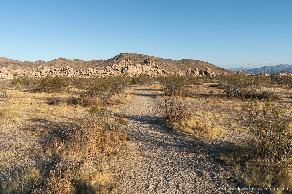
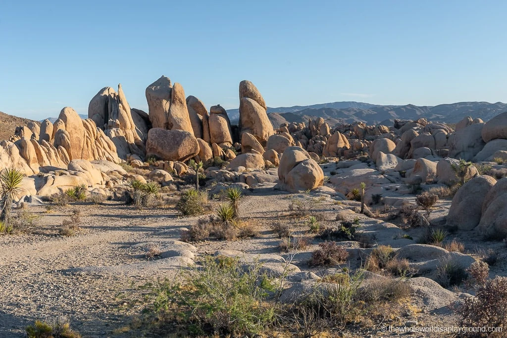
Before we visited Joshua Tree National Park we tried to find directions to Heart Rock however we found it difficult to establish its exact location. We knew it was somewhere near Joshua Tree’s famous Arch Rock but, in a barren desert landscape filled with boulder upon boulder, that still left a lot of ground to cover! There isn’t any signposting leading to Heart Rock although the Arch Rock trail is well marked – you can check out our guide to the Arch Rock trail for more detail.The Arch Rock trailhead parking lot The hike to Heart Rock is a short detour off the Arch Rock hiking trail. The Arch Rock hiking trail is an out and back trail that leaves from the Twin Tanks/Arch Rock trailhead parking lot. The Arch Rock trail is around 0.5 miles each way and takes around 20 minutes each way (assuming you don’t get lost as we did!). Heart Rock is located to the northeast of Arch Rock up the hill on top of a level section of rock. The detour from the Arch Rock trail is around 15 minutes round trip but you’ll also spend time at Heart Rock taking photos and enjoying the views! Hiking to Heart Rock is one of our favorite things to do in Joshua Tree!
How to get to Heart Rock tip: While it is possible to hike to Arch Rock and Heart Rock from the White Tank Campground, we don’t recommend trying to as it is extremely difficult to get a parking spot at the campground. The campground was closed to car access when we visited. It’s much easier to get a parking spot at the larger designated parking lot further down the road and making the 1-mile round trip hike.
Hiking to Heart Rock
The hike to Heart Rock begins at the Twin Tanks/Arch Rock parking lot located just off the Pinto Basin Road. There is parking for around 30 cars. Follow the trail from the parking lot, cross the road and take the first right turn on the Arch Rock trail. After this turn, you’ll be walking across open ground towards the rocky outcrop where Arch Rock is located.The Arch Rock trail en route to the rocks As you reach the rocky area you will see a junction in the trail, with Arch Rock trail marked as straight on and to the right -the Arch Rock trail is a loop so there are two routes which lead to the rock. For Heart Rock, take the left turn (the orange line on the map) and head up the incline over the rock towards the hillside where Heart Rock is located.As you approach the rocks at Arch Rock the route to Heart Rock turns left here From the turn It is a straight hike up the incline to Heart Rock. You’ll know you are going the right way if you cross a dry river bed and remain on the rough trail up to Heart Rock between the large rocks. If you are scrambling across rocks then you’ve probably taken a wrong turn into the rocky areas. Avoid heading into the large rocks to the left or right and you should reach Heart Rock after around 400 to 500 metres. The rock itself is on a relatively flat area. If you wander left or right into the deeper rock it is very hard to see Heart Rock.This is the first view you’ll see of Heart Rock (from the west side)
Heart Rock
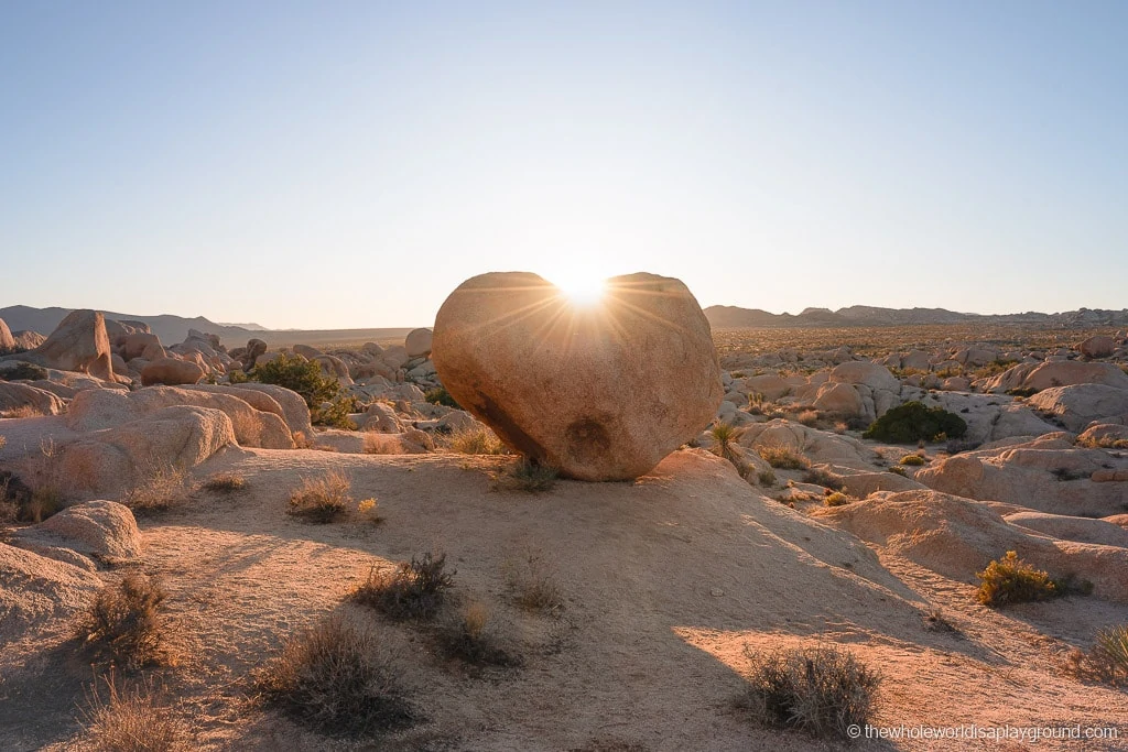
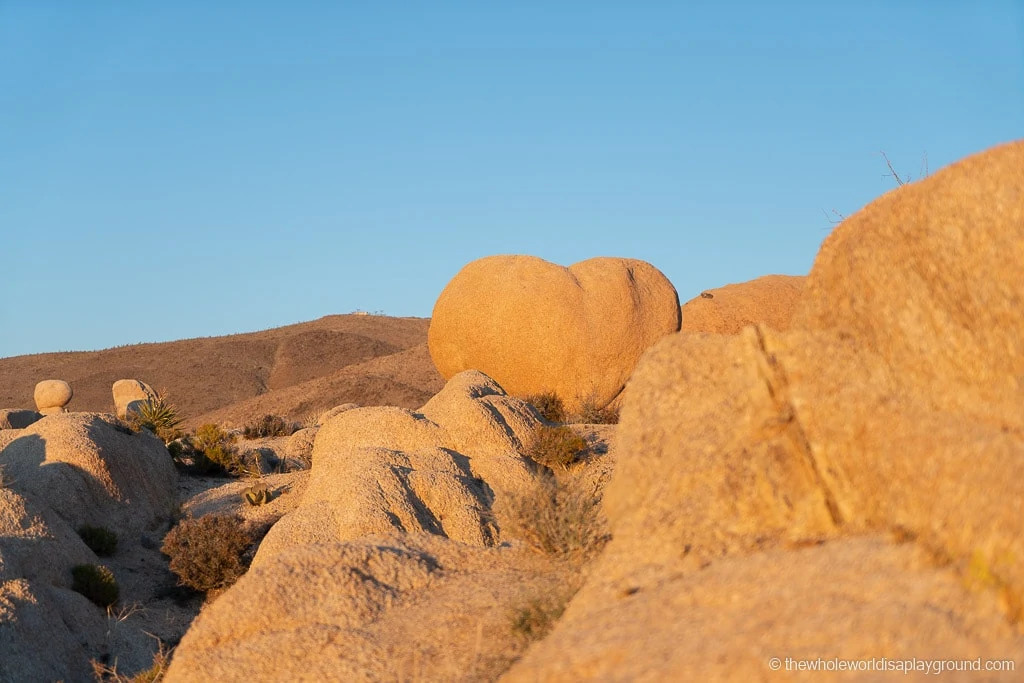
Heart Rock faces both east and west but we preferred the view from the east side best as it overlooks the Joshua Tree landscape. The rock is more perfect heart shaped from this side. We visited Heart Rock twice: once for sunset and once for sunrise. Sunset was perfect for capturing the rock with the sun setting in the west behind the rock. We were lucky to get a beautiful sunset when we visited.The sun setting behind Heart Rock
How to get to Heart Rock: If you visit for sunset remember that if you spend a lot of time at heart rock that you will be hiking back to your car in the dark so bring a flashlight, preferably a head torch. We were thankful to have our head torch for the walk back to our car as it was almost completely dark by the time we made the hike back
The view of the west side of Heart Rock at sunset Sunrise is better for capturing people photos at Heart Rock as the early morning light during golden hour hits the front face of the rock. As the rock is located on a hillside the light won’t actually hit Heart Rock for at least 30 minutes after sunrise.Heart Rock at sunrise
Arch Rock
If you visit Heart Rock first don’t forget to stop at Arch Rock on the way back to your car. We had so much fun at Heart Rock we almost forgot to visit the famous Arch Rock but we were glad we made time for both! The hike to Heart Rock and Arch Rock are one of our favorite things to do in Joshua Tree National Park!Arch Rock, Joshua Tree National Park
9 thoughts on “How to get to Heart Rock, Joshua Tree”
Thank you thank you for the awesome directions and exact gps coordinates. We were easily able to find the heart rock and it was our first time in the park! So happy I stumbled across your blog and will definitely be following for future trips
Heart rock was easy to locate. When you take left fork going clockwise in the looping trail to Arch rock you should see Heart Rock up the hill side from the first nature trail marker you come to. Just head down the hill from the arch rock trail, thru the dry river bed and up the hill. Once you are out of the dry river bed you should be able to see the Heart rock all the rest of the way. Be sure to follow the unmarked trail traveled by those before you.


Thank you thank you for the awesome directions and exact gps coordinates. We were easily able to find the heart rock and it was our first time in the park! So happy I stumbled across your blog and will definitely be following for future trips
Thanks Jennifer, so glad you found it useful!
Heart rock was easy to locate. When you take left fork going clockwise in the looping trail to Arch rock you should see Heart Rock up the hill side from the first nature trail marker you come to. Just head down the hill from the arch rock trail, thru the dry river bed and up the hill. Once you are out of the dry river bed you should be able to see the Heart rock all the rest of the way. Be sure to follow the unmarked trail traveled by those before you.
Thanks Dennis, always great to hear from someone who has been out to Heart Rock
Question is it hard tiering to get there? I have hip surgery but I would love to go with my kids. Just scared it’s hard.
Hi Liza
The ground is uneven and there’s no designated path but it is relatively flat.
Hope that helps
Elaine
Thanks to you and your blog, I was able to find the rock, and even get a photo of a shooting star above it! THANKS!!!!!!
We found heart rock easily with the coordinates you gave, and there was one other couple hiking there. Thank you for your directions and description!
Nps now has this marked. Start hiking out to arch rock and you will see the marker pointing the way to heart rock